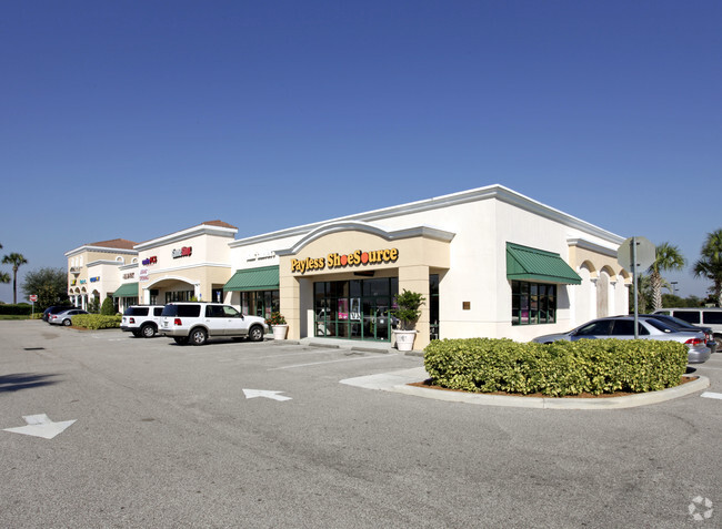
Property Record
8530 N Wickham Rd, Melbourne, FL 32940

NEARBY LISTINGS FOR SALE OR LEASE
Property Detail
8530 N Wickham Rd
Palm Bay-Melbourne-Titusville, FL
Wal-Mart At Viera
26-36-09-SU-00000.0-0004.00
WAL-MART AT VIERA LOT 4 EXC THAT PT OF LOT 4 DESC IN ORB 4209 PG 2331 LYING WITHIN ORB 3003 PG 2817, 2820
Storebuilding
Brevard
A
Florida
12009C0505G
4
2024
1.74 AC
2025
Brevard County
071201
Orlando
13,472 SF
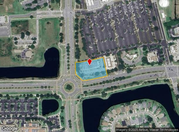
DEMOGRAPHICS near 8530 N Wickham Rd
1 Mile
3 Mile
5 Mile
2024 Total Population
6,329
46,667
74,727
2029 Population
7,219
51,665
82,115
Pop Growth 2024-2029
+ 14.06%
+ 10.71%
+ 9.89%
Average Age
41
46
46
2024 Total Households
2,405
19,278
30,916
HH Growth 2024-2029
+ 13.60%
+ 10.21%
+ 9.55%
Median Household Inc
$103,233
$96,901
$97,481
Avg Household Size
2.60
2.40
2.40
2024 Avg HH Vehicles
2.00
2.00
2.00
Median Home Value
$443,819
$389,750
$375,411
Median Year Built
2010
2003
2001
Nearby Places
Map Layers
Map Styles
 Street
 Aerial
- Restaurants
- Banks
- Shops
- Fitness
- Groceries
PUBLIC TRANSPORTATION
AIRPORT
Melbourne Orlando International
DRIVE
WALK
Distance
Melbourne Orlando International
25 min
14.8 mi
Freight Ports
Port Canaveral
DRIVE
WALK
Distance
Port Canaveral
34 min
24.5 mi
SALE & LEASE HISTORY
LISTING DATE
SALE/LEASE

Sep 25, 2016
For Lease
Mar 04, 2021
For Lease
Jan 11, 2017
For Lease
Nearby Properties
Address
Land Use
TOTAL SIZE
Lot Size
Zoning
Address
Land Use
TOTAL SIZE
Lot Size
Zoning
453,736 SF
50 AC
PUD
Address
Land Use
TOTAL SIZE
Lot Size
Zoning
520,272 SF
17.31 AC
Address
Land Use
TOTAL SIZE
Lot Size
Zoning
460,019 SF
11.64 AC
Address
Land Use
TOTAL SIZE
Lot Size
Zoning
406,986 SF
30.50 AC
PUD
Address
Land Use
TOTAL SIZE
Lot Size
Zoning
381,303 SF
9.93 AC
Address
Land Use
TOTAL SIZE
Lot Size
Zoning
395,806 SF
12.95 AC
Address
Land Use
TOTAL SIZE
Lot Size
Zoning
359,896 SF
13.29 AC
Address
Land Use
TOTAL SIZE
Lot Size
Zoning
358,615 SF
14.78 AC
PUD
Address
Land Use
TOTAL SIZE
Lot Size
Zoning
276,647 SF
2.39 AC
Address
Land Use
TOTAL SIZE
Lot Size
Zoning
386,565 SF
11.90 AC
Address
Land Use
TOTAL SIZE
Lot Size
Zoning
308,045 SF
45.57 AC
PUD
Address
Land Use
TOTAL SIZE
Lot Size
Zoning
353,805 SF
44.02 AC
PUD
Address
Land Use
TOTAL SIZE
Lot Size
Zoning
439,660 SF
38.05 AC
PUD
Address
Land Use
TOTAL SIZE
Lot Size
Zoning
224,695 SF
5.26 AC
Address
Land Use
TOTAL SIZE
Lot Size
Zoning
269,541 SF
17.80 AC
PUD
Address
Land Use
TOTAL SIZE
Lot Size
Zoning
134,562 SF
18.25 AC
BU1
Address
Land Use
TOTAL SIZE
Lot Size
Zoning
16.29 AC
GML
Address
Land Use
TOTAL SIZE
Lot Size
Zoning
244,587 SF
8.49 AC
Address
Land Use
TOTAL SIZE
Lot Size
Zoning
375,112 SF
30.84 AC
PUD
Address
Land Use
TOTAL SIZE
Lot Size
Zoning
202,791 SF
32.03 AC
GML
Address
Land Use
TOTAL SIZE
Lot Size
Zoning
136,205 SF
28.71 AC
PUD
Address
Land Use
TOTAL SIZE
Lot Size
Zoning
324,509 SF
23.54 AC
GMLI
Address
Land Use
TOTAL SIZE
Lot Size
Zoning
38.68 AC
GML
Address
Land Use
TOTAL SIZE
Lot Size
Zoning
125,958 SF
17.10 AC
Address
Land Use
TOTAL SIZE
Lot Size
Zoning
205,351 SF
42.36 AC
GU
Address
Land Use
TOTAL SIZE
Lot Size
Zoning
149,868 SF
5.42 AC
PUD
Address
Land Use
TOTAL SIZE
Lot Size
Zoning
162,977 SF
11.44 AC
GML
Address
Land Use
TOTAL SIZE
Lot Size
Zoning
132,310 SF
19.92 AC
PUD
Address
Land Use
TOTAL SIZE
Lot Size
Zoning
110,664 SF
10 AC
PUD
Address
Land Use
TOTAL SIZE
Lot Size
Zoning
114,906 SF
16.85 AC
PUD
The World's #1 Commercial Real Estate Marketplace
Connect with us
© 2025 CoStar Group
The information above has been obtained from sources believed reliable. While we do not doubt its accuracy we have not verified it and make no guarantee, warranty or representation about it. It is your responsibility to independently confirm its accuracy and completeness. Any projections, opinions, assumptions, or estimates used are for example only and do not represent the current or future performance of the property. The value of this transaction to you depends on tax and other factors which should be evaluated by your tax, financial, and legal advisors. You and your advisors should conduct a careful, independent investigation of the property to determine to your satisfaction the suitability of the property for your needs.